

August 2017 (through Aug. 28) surface temperature anomalies around North America (NCEP CFSv2, courtesy of Weatherbell.com).
As the Houston flood disaster is unfolding, there is considerable debate about whether Hurricane Harvey was influenced by “global warming”. While such an issue matters little to the people of Houston, it does matter for our future infrastructure planning and energy policy.
Let’s review the two basic reasons why the Houston area is experiencing what now looks like a new record amount of total rainfall, at least for a 2-3 day period over an area of tens of thousands of square miles.
1) A strong tropical cyclone, with access to abundant moisture evaporated off the Gulf of Mexico, and
2) Little movement by the cyclone.
These two factors have conspired to create the current flooding catastrophe in Houston. Now let’s look at them in the context of global warming theory.
1. Are Texas major hurricanes dependent on an unusually warm Gulf?
I examined all of the major hurricane (Cat 3+) strikes in Texas since 1870 and plotted them as red dots on the time series of sea surface temperature variations over the western Gulf of Mexico. As can be seen, major hurricanes don’t really care whether the Gulf is above average or below average in temperature:
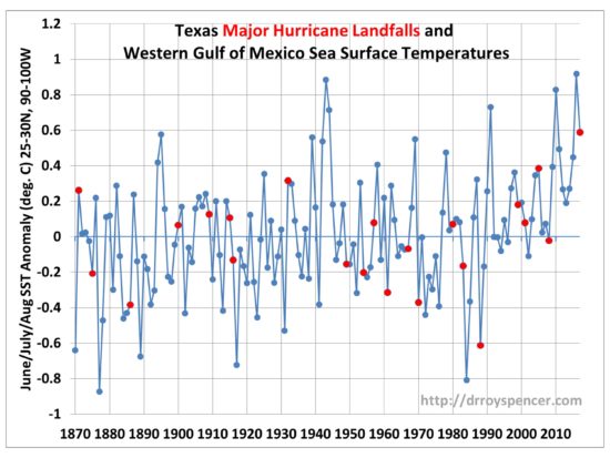
Red dots indicate years of major hurricane strikes in Texas, plotted on average SST departures from normal by year over the western Gulf of Mexico (25-30N, 90-100W).
Why is that? It’s because hurricanes require a unique set of circumstances to occur, and sufficiently warm SSTs is only one. (I did my Ph.D. dissertation on the structure and energetics of incipient tropical cyclones, and have published a method for monitoring their strength from satellites).
The Gulf of Mexico is warm enough every summer to produce a major hurricane. But you also usually need a pre-existing cyclonic circulation or wave, which almost always can be traced back to the coast of Africa. Also, the reasons why some systems intensify and others don’t are not well understood. This is why the National Hurricane Center admits their predictions of intensity change are not that accurate. Lots of thunderstorm complexes form over warm tropical waters, and we still don’t understand why some of them will spontaneously form a cyclonic circulation.
2. Does global warming cause landfalling hurricanes to stall?
I don’t know of any portion of global warming theory that would explain why Harvey stalled over southeast Texas. Michael Mann’s claim in The Guardianthat it’s due to the jet stream being pushed farther north from global warming makes me think he doesn’t actually follow weather like those of us who have actual schooling in meteorology (my degree is a Ph.D. in Meteorology). We didn’t have a warm August in the U.S. pushing the jet stream farther north.
In fact, I dare anyone to look at the August temperature anomalies to date in the U.S. (courtesy of Weatherbell.com) and tell me, exactly what pattern here is due to global warming?
The flooding disaster in Houston is the chance occurrence of several factors which can be explained naturally, without having to invoke human-caused climate change. We already know that major landfalling hurricanes in the U.S. have been less frequent in recent decades. But once one forms, if it stalls near the coast (a rarity), it can be expected to cause a flooding disaster…especially in a flood-prone area like Houston.
Ref.: http://www.drroyspencer.com/2017/08/texas-major-hurricane-intensity-not-related-to-gulf-water-temperatures/
……………………
Double whammy for Texas? Another Tropical System may form in the Gulf
Still very early, but enough concern from the National Hurricane Center, to talk about it in their 5 day outlook.
See the yellow patch, worth watching closely as the forecast develops.

An area of low pressure could form over the southwestern Gulf of Mexico by the weekend. Development, if any, of this system is expected to be slow to occur as the low moves slowly northward.
If this system does develop, it could bring additional rainfall to portions of the Texas and Louisiana coasts. However, any rainfall forecast is uncertain at this time range and it is too soon to determine any specific impacts. Interests in these areas should monitor the progress of this system for the next few days.
* Formation chance through 48 hours…low…near 0 percent.
* Formation chance through 5 days…low…20 percent.
