By Cap Allon – Electroverse
The weekend’s historic Arctic front brought significant snowfall to many regions of North America, particularity to southern Canada and Midwest/Western United States.
“Leading up to its arrival, we were talking about how this could be a major event,” said CMOS Accredited Weathercaster Chris Sumner, “but it’s nearly unbelievable some of the snowfall totals we’re hearing about considering the time of year it is.
“When you look at these numbers, and combine the fierce winds we experienced, it becomes clear very quickly why Manitoba Hydro is dealing with the damage it is right now.”
Below are some of the crazy snow totals reported at Environment Canada stations over the weekend:
- Carberry: 74 cm (29 inches)
- Morden: 64 cm (25 inches)
- Strathclair: 61 cm (24 inches)
- Treherne: 60 cm (23.6 inches)
- Holland: 58 cm (22.8 inches)
- Miami: 50 cm (19.7 inches)
- McCreary: 45 cm (17.7 inches)
- Dunrea: 40 cm (15.7 inches)
- Winnipeg: 34 cm (13.4 inches)
- Wasagaming: 33 cm (13 inches)
- Douglas: 31 cm (12.2 inches)
- Dauphin: Rosser: 30 cm (11.8 inches)
- Brandon: 29 cm (11.4 inches)
Winnipeg’s mayor declared a state of local emergency following the devastating blizzard that damaged thousands of trees, left more than 150,000 homes without power and brought the city to a near standstill.
“The City of Winnipeg has experienced an unprecedented weather event with strong winds and heavy snowfall,” reads Mayor Brian Bowman’s official declaration in part. “[The storm] continues to require prompt action to prevent or limit harm or damage to the safety, health or welfare of residents.”
The state of emergency will last until at least Nov. 12.
Manitoba Premier Brian Pallister has since declared a full-blown province-wide state of emergency allowing recovery crews additional support and funding to deal with the aftermath of the record-breaking storms.
After the clear-up, concerns will turn to “overland flooding and rising rivers and streams,” says Sumner.
UNITED STATES
Early snowstorms in Montana are being linked to the deaths of five grizzly bears.
The bears were feeding on the carcasses of cattle that had been caught in a late September blizzard on the Blackfeet Indian Reservation. Cold weather and snow had resulted in a loss of some of the bears’ natural autumn food sources like chokecherries, said Montana’s Department of Fish, Wildlife & Parks.
In neighboring North Dakota, this year’s harvest has been brought to a complete standstill after farmers were buried under 30+ inches of snow on Thursday, Friday, Saturday AND Sunday.
As of October 7, so before this weekend’s Arctic front even blew through, the National Agricultural Statistics Service reported the percentages of crops unharvested: CORN was at 100% with only 22% mature; SOYBEANS was at 92%; SPRING AND DURUM WHEAT at around 20%; CANOLA at 31%; FLAXSEED at 37%; SUGAR BEETS at 81%; and POTATOES at 55%.
The majority of this produce is now buried in the fields.
“I can’t blow it,” said Mike Clemens, a farmer in Wimbledon, N.D.. “[It’s] too much for my Massey Ferguson-11 loader. Snow is wet and heavy. My guess is the soybeans are full of snow, 12 inches deep. Ditto for the corn with snow banks [4+ feet high] on the west and north sides.”
It’s a dead cert the crops will sustain irreparable damage.
And the story is the same for farmers across the Northwest/Midwest.
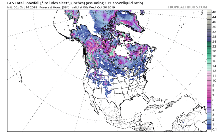
As it is over the border and into Canada too, where yet more HISTORIC snow is expected through the rest of October; with the province of British Columbia set to be worst hit — a staggering 11 foot (3.4 meters) is forecast to fall here:
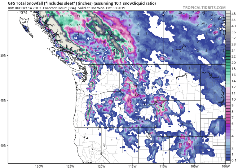
All this deep settled snow will sink temperatures even lower, assisting in driving the snow line anomalously-far south.
Even the likes of New Mexico and Texas could receive substantial early-season snow on or around the 21st of the month:
The cold times are returning in line with historically low solar activity.
NASA has revealed this next solar cycle (25) will be “the weakest of the past 200 years” and have tied previous solar shutdowns to prolonged periods of global cooling here.
Ref.: https://electroverse.net/north-america-suffers-unbelievable-snowfall-totals/
Related: JAMESTOWN, NORTH DAKOTA DIGS OUT FROM RECORD BREAKING SNOWFALL: “[WE’VE] NEVER SEEN ANYTHING LIKE THIS BEFORE”
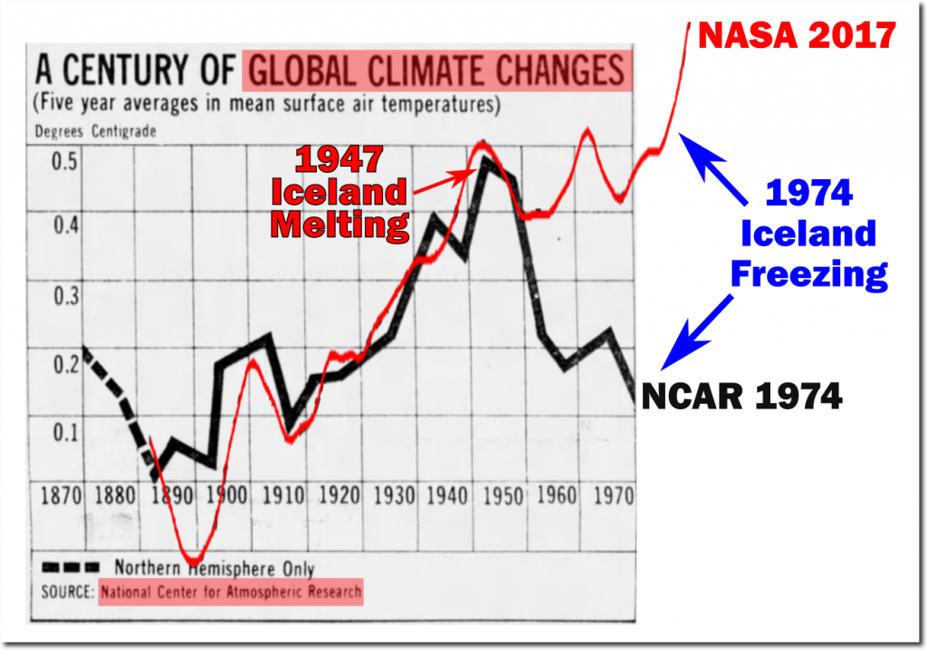
More snow and more cold weather, does anyone believe it is caused by warming?
According to what we all can observe, – empirically on the ground, the red line in the graph is obviously as FAKE as everything else coming from the left and their activist minions.